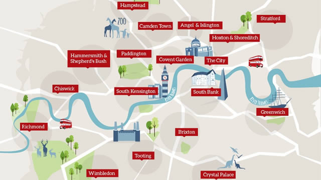
Riverside Walks and Runs

A walk or run along the Thames offers easy, level ground - ideal for a gentle afternoon stroll or a brisk jog.

Public transport reaches the whole length of the Thames and London's other waterways. You are spoiled for choice as to possible routes and the wealth of history, architecture, world-famous buildings and inspirational views.

Best of all, if you get tired you can catch a boat service back to where you started. Another agreeable option is to stop off at one of the many waterside pubs or restaurants for much-needed refreshments.

Read more about walking in our Travel section.

The Thames Path

The Thames Path is a National Trail that runs on each bank of the river through the city, but you can cross over easily to the opposite bank by the many bridges along the route.

The trail follows the river for 296km (184 miles) all the way from its source in the Cotswolds through rural countryside and into the urban landscape of Central London, finishing at the Thames Barrier in Woolwich.

But you don't have to stick to the Thames Path. There are other waterways that are well worth a visit and plenty of interesting sights that merit a detour away from the river's banks.

For detailed information about the Thames Path call the National Trails office on +44 (0)1865 810224 or visit its Thames Path website.

Selected Routes

Given the length and diversity of the Thames and London's waterways, it would be impossible to give a comprehensive list of walks here. But we've selected three routes that we think are of interest, and that cover some lesser-known areas. Download the relevant guide (see related links below), get your trainers on and get walking!

Exploring London's Working River Guide

This guide covers 4 walks of between 2km (1.25 miles) and 6km (3.75 miles), from the Thames Barrier eastwards to Crayford Ness. The themes are Galleons and Guns, From Sail to Steam, Of Motor Cars and Marshes and Erith to QEII Bridge.

Walking the East End's Canals Guide

A 5-mile walk, revealing the hectic past of the canals' heyday, contrasted with the peace and tranquillity of today's surroundings. The walk takes in parts of the Regent's Canal, Grand Union Canal, Limehouse Cut and River Lee Navigation.

Walking in the Lee Valley Guide

This is a 4-mile walk combining historical charm, open space and abundant wildlife. The Lee Valley covers an amazing 4,000 hectares (10,000 acres) of regional parkland.

Find out more about the locations covered by these walks in our River & Waterways by Area section. You'll also find inspiration and information on the Visit Thames website.

Useful Tips

  • The Thames Path is clearly signposted along its length with the distinctive National Trail acorn symbol alongside its name. There are also signs along the route pointing out the direction of nearby villages and attractions.
  • It is always a good idea to take a detailed map, an A-Z or both when walking along the Thames or the canals, particularly in unfamiliar areas.
  • You can enjoy the Thames's riverside paths at any time of year. Comfortable shoes or trainers are suitable for gentle walking and jogging in the summer but, in the wet months out in the more rural sections of the riverside, it is advisable to put on wellies or walking boots.
  • As with any excursion anywhere, use your common sense and be aware of your personal safety. Be careful when walking along quiet or unlit streets.
 

Questions About Riverside Walks and Runs

powered by Yedda
  • Platinum Partner
    Covent Garden London
  • Platinum Partner
    The Royal Parks
  • Platinum Partner
    Chelsea Football Club
  • Platinum Partner
    Collins